


COURNIOLE

CANON2
User
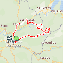

Length
15.1 km

Max alt
972 m

Uphill gradient
456 m
Km-Effort
21 km

Min alt
671 m

Downhill gradient
457 m
Boucle
Yes
Creation date :
2019-05-15 13:10:47.285
Updated on :
2019-05-15 13:10:47.364
3h45
Difficulty : Medium

FREE GPS app for hiking
 SityTrail
IGN / Geographical institutes
SityTrail Plus
The world is yours!
About
Trail Walking of 15.1 km to be discovered at Occitania, Hérault, La Salvetat-sur-Agout. This trail is proposed by CANON2.
Positioning
Country:
France
Region :
Occitania
Department/Province :
Hérault
Municipality :
La Salvetat-sur-Agout
Location:
Unknown
Start:(Dec)
Start:(UTM)
475939 ; 4827637 (31T) N.
Comments